Data processing
Geographic information system
Hydro GeoAnalyst
Hydro GeoAnalyst 2013 is a tool for design, evaluation and presentation of geological data, with ability to directly export reports in Excel or PowerPoint formats.
Powerful tool for processing, analyzing and visualizing environmental data.
Hydro GeoAnalyst is an all-in-one software, allowing easy organization, management and interpretation of geological, hydrogeological, geophysical and environmental data using a comprehensive and flexible SQL Server database technology.
Overview
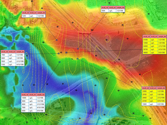
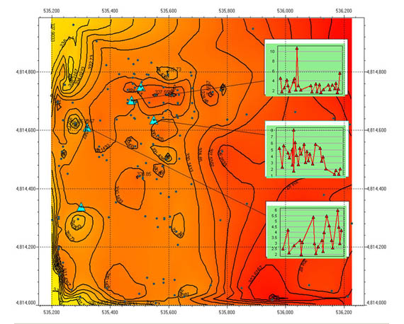
GIS type software provides high level hydrogeological project management and data interpretation. It is an all-in-one concept with a large number of tools for data processing including:
- Data Transfer System,
- Query Editor,
- GIS Map Manager,
- 2D Cross-Section Editor,
- 3D-Explorer,
- Template Manager,
- Report Editor and much more!
Hydro GeoAnalyst Flexibility
- Content and structure of the SQL Server database
- Content and structure of the borehole profile
- Form of interpretation of the results according to your requirements
- Refilling and/or removing tables or data fields
- ZProcessing an unlimited number of database tables and descriptive characteristics pf hydrogeological samples
- Insert the modified structure of the database files and templates in all new projects
Scale of Hydro GeoAnalyst
Hydro GeoAnalyst is focused on evaluation and interpretation of geological survey data and has the only limitation in the number of point information - boreholes. The limitation is defined by common interpretive fidelity of spatial projections and also depends on individual area of interest. Individual Hydro GeoAnalystIt projects can incorporate data from 4 to 4 000 boreholes.